Home
Town centre proposals
Introduction to the town centre
The town centre is the historic heart of Farnham. It has a dynamic economy with high quality retail, food and drink venues, and a unique heritage with the castle, conservation area, deer park and craft town status.
However, its road layout is outdated and congested. The dominance of roads and vehicles negatively impacts the ability to travel easily, safely, and enjoyably around the town centre on foot and by bus or cycle, resulting in a less pleasant environment and a diminished sense of place.
The Farnham Infrastructure Programme has two town centre proposals showing different ways to address this. They both feature wider and repaved pavements, supported by the removal of unnecessary street clutter. This means space for new planting, public seating and outside dining to make the town centre a nicer environment to visit and spend leisure time. More cycle parking in key locations in the town centre will help people to use bikes to get to town. The proposals do not prevent a wider pedestrianisation scheme being taken forward in the future.
Proposal A is Castle Street and Downing Street, and proposal B is changes to the traffic flow and The Borough. You can read through both proposals and answer the consultation questions by clicking through the pages below.
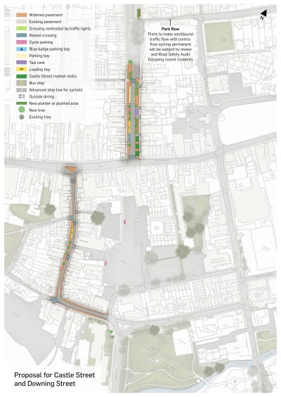
Proposal A: Castle Street and Downing Street
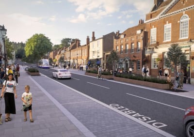
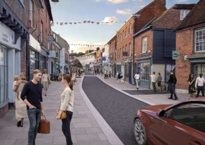
This proposal involves making the temporary arrangements in Castle Street and Downing Street permanent alongside other improvements. Castle Street will stay two-way, but the road will be narrowed; while Downing Street will permanently become a single lane, one-way road. The changes will mean wider pavements for pedestrians, alongside space for outdoor dining, new trees and planting, and retailers’ deliveries.
Pros
- Respects the town centre’s heritage
- Wider pavements for pedestrians, which are safer for people with disabilities or with pushchair
- Space for more cafés, pubs, bars and restaurants to have outdoor seating where appropriate
- Loading bays for retailers to prevent the road becoming blocked
- Improved appearance of the town with greening and new planting
- No change to road capacity as it formalises the layout introduced during the Covid 19 pandemic
Cons
- Limited benefits for the wider town centre as only improves Castle Street and Downing Street
Castle Street
Our proposal for Castle Street formalises the current layout introduced during the Covid 19 pandemic which narrows the wide carriageway at the southern end to create wider pavements. There will be raised pedestrian crossings between Long Garden Walk and the Giggling Squid, and at the bottom of Castle Street at the junction with The Borough. The bus stops will remain but will be located within the traffic lane rather than in a separate bay.
On the eastern side of Castle Street, the pavement will be widened to create space for outdoor dining outside the Nelson Arms, and then south from the Giggling Squid to The Borough. On the western side, widened pavements will start at the bus stop outside the Castleton Dental Practice and then south to the junction with the Borough.
The proposal includes:
- The potential for cycle parking outside ME Estate Agents, the Castleton Dental Practice and Bill’s restaurant
- Maintaining the existing parking spaces from just south of Long Garden Walk to Trueman & Grundy estate agents
- Taxi parking bays outside Alan Greenwood and Sons (or relocated to East Street or West Street)
- New space for outdoor dining outside Pizza Express and the Giggling Squid
- A loading bay outside The Castle Inn and part of Hamptons estate agents
- Blue badge parking spaces outside the lower part of Hamptons estate agents, Gail’s, and Caffe Nero.
See below for a detailed map and to answer the consultation questions.
Downing Street
The improvements to Downing Street are proposed to start from the junction with Long Bridge and Union Road and run along the length of the road to the junction with West Street. This proposal formalises the existing temporary road layout, so it will remain a single lane, one-way road with pavements widened wherever possible.
There will be new raised pedestrian crossings on the western side, crossing Lower Church Lane and Upper Church Lane. The current pelican crossing will be removed and replaced with raised pedestrian crossings between Farnham Wholefoods and Smallbone and Sons, and between Lower Lodge Candles and Loaf.
The proposal includes:
- Loading bays outside The Lost Boy, and outside Wallababies, Loncherie, and The Establishment
- Wider pavements for pedestrians
- Four new trees between the Ceramics Café and The Frame Centre
- More space for outside dining if appropriate.
See below for a detailed map and to answer the consultation questions.
Check out the following documents
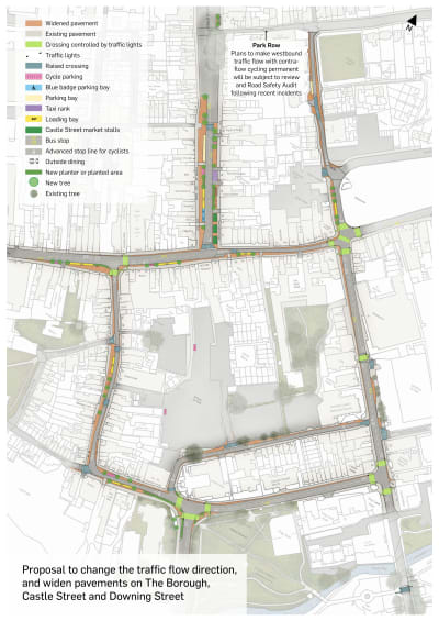
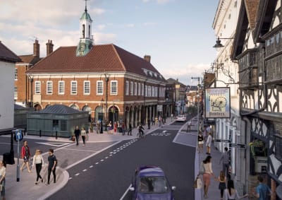
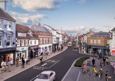
Proposal B - changing traffic flow and widening pavements
This proposal will widen pavements and provide new and improved crossings around the town centre for pedestrians, alongside space for cycle parking, new trees and planting, and retailers’ deliveries. It will also change the traffic flow, so some roads that are currently one-way would become two-way. This would remove the need for some vehicles to circulate unnecessarily around the town.
Pros
- Respects the heritage of the town
- Wider pavements for pedestrians, which are safer for people with disabilities or with pushchairs, particularly in The Borough, Victoria Road, Union Road, part of West Street and parts of South Street
- Shorter driving routes for some people, such as people from north Farnham using the Hart car parks.
- New and improved crossing points at most town centre junctions
- Raised crossings in The Borough, Victoria Road and Brightwells Road
- Loading bays for retailers in The Borough and West Street to prevent the road becoming blocked
- Improved appearance of the town with greening and new planting
Cons
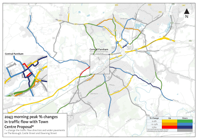
- Some displacement of traffic to outer neighbourhoods as shown in the modelling
- No segregated cycle paths in the town centre
Click 'Next' below to continue reading and to answer the consultation questions.
Changing the traffic flow
Under this proposal, two-way traffic will be permitted along South Street, Union Road, and The Borough between Downing Street and Castle Street. The Borough, between Castle Street and the Royal Deer Junction, and Downing Street would remain one way for vehicles.
Changing the traffic flow will mean some drivers won’t need to drive as far around the town centre to reach their destination. For example, drivers travelling down Castle Street will be able to turn right and use The Borough and West Street to access the Hart car parks.
Please see the separate briefing on Castle Street and Downing Street for the proposals for those roads.
West Street and The Borough
Under these proposals, The Borough will become two-way between West Street and Castle Street, and remain one-way between Castle Street and the Royal Deer Junction.
Pavements will be widened on the southern side of West Street from Elphicks to the junction with Downing Street, and then along both sides of The Borough to the Royal Deer Junction. There will be signalised crossing points at the junction with Downing Street and at the Royal Deer Junction, but the existing pelican crossing in The Borough will be removed.
There will be:
- Cycle parking outside SpaceNK and JojoMamanBebe
- Loading bays outside Holland & Barrett, Clarks, HSBC bank and Vodafone
- Bus stops will be moved to outside Elphicks westbound and outside Salon Cabelo and Bloom eastbound.
South Street
It is proposed that South Street becomes a two-way road. The pelican crossing will be moved to just north of the exit to Sainsbury’s car park, and there will be raised pedestrian crossings at the Sainsbury’s car park exit, and the junctions at Brightwells Road and Victoria Road. The junction with Union Road will be controlled by traffic lights and will include crossing points.
A northbound bus stop will be in front of the small parade of shops adjacent to the Bush Hotel car park, while the southbound bus stop will remain outside Sainsbury’s but will be in the road, rather in a layby.
There will be a new raised pedestrian crossing connecting Borelli Walk and Gostrey Meadow.
Union Road and Victoria Road
Union Road will become two-way until the junction with Downing Street and Long Bridge which will become controlled by traffic lights with crossing points. Victoria Road will remail one-way. Pavements will be widened pavement on the north side of both Union Road and Victoria Road
Bear Lane
Bear Lane will remain one-way. There will be widened pavements all the way up to the junction with Park Row, with some cycle parking and raised pedestrian crossings.
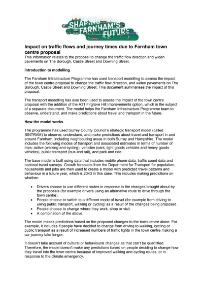
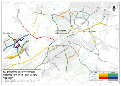
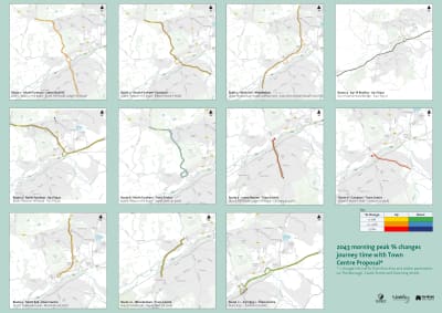
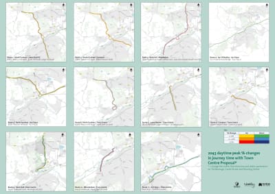
Transport modelling
The Farnham Infrastructure Programme has used transport modelling to assess the impact of this proposal and A31 corridor options. The models help the Farnham Infrastructure Programme team to observe, understand and make predictions about travel and transport.
Please read the detailed traffic modelling in the document below for more information.
Complementary measures
Changing the traffic flow and introducing traffic lights to some junctions will reduce capacity on the roads in the town centre. Therefore other measures will be necessary to help reduce the number of cars on the roads.
A key way of doing this is by supporting and encouraging people in Farnham to reduce their car use, and walk, cycle or take public transport instead whenever possible. Please read our briefing on active and sustainable travel.
Local area studies
If the consultation highlights that people in Farnham would like this proposal to be implemented, the Farnham Infrastructure Programme team has committed to reviewing the modelling and looking for solutions to mitigate the impact of traffic displacement. There would be studies of both north and south Farnham.
Possible interventions listed in the Optimised Infrastructure Plan include:
- Pavement widening and road narrowing
- School safety zones
- Increased 20mph zones, particularly outside schools and in residential areas.
- Junction alterations, including Upper Hale and Farnborough Road, Alma Lane and Farnborough Road, and the Water Lane roundabout
Check out the following documents
This engagement phase has finished

...